|
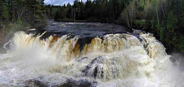
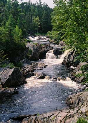
The Grand Falls of The Dead River – Driving and Snowmobile Access – Easy Walk – 0.5 miles
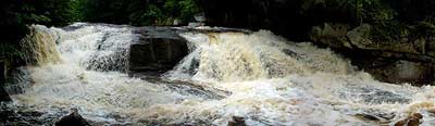
Grand Falls is an amazing waterfall unknown to many. The falls are just upstream from the rafting put-in for all whitewater trips on the Dead River – but you can’t see anything from your raft by looking upstream. The Grand Falls just happen to be “hiding" around a corner out of view!
Just upstream of the falls is one of the huts that make up the Maine Huts & Trails System. The “Grand Falls Hut", and others like it, are one of four currently in-place throughout the western Maine Mountains. This system of trails and huts is growing constantly. So, for more information on the Maine Hut and Trail system, please visit their website at; http://www.mainehuts.org/.
Grand Falls is also right along Maine’s ITS 89 snowmobile trail – so it’s now as popular a destination in the winter as in the summer. Best of all, the falls can easily be visited by snow machine right from North Country Rivers. In the summer, you can also drive to the falls and see them with minimal walking..
DIRECTIONS: Turn left (north) out of the NCR parking lot and follow Route 201 through Bingham and on to The Forks. Continue north on Route 201 for 2.5 miles, and then turn left onto The Lower Enchanted Road; a dirt logging road. Follow the Lower Enchanted Road to mile 4.7 where the road splits. Stay to the left-split on The Lower Enchanted Road. Continue straight past through intersections and bearing to the left in places wherever the road splits. At approximately mile 14 there is a large clearing and a small kiosk building. Pass the kiosk for a short distance and you will reach The Dead River. At the bottom of the hill you can park your car, and walk across the metal bridge over a stream that empties into The Dead River. Follow the obvious trail along the banks of The Dead River for only a few hundred yards to an overlook of Grand Falls.
CAUTION: Logging trucks have the right of way on these dirt roads. They are owned by private lumber companies who must allow public access, but travelers still must yield to ALL logging traffic.
DIRECTIONS BY SNOWMOBILE: Go north on the ITS 87 from the North Country Rivers Kennebec-Dead Base, to the Forks. From The Forks, follow the ITS 86 west to the ITS 89 junction. From this junction take the 86/89 west. After you cross Spencer Stream bridge (a large steel bridge in view of The Dead River), proceed up the hill a few hundred yards and look for the falls on your left.
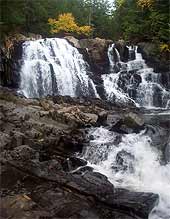
Pierce Pond Stream (Falls and Gorge) – Moderate – 3 miles
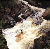
This spectacular “hidden jewel" is on the Appalachian Trail. and even as this scenic location provides great hiking, wildlife watching, and many waterfalls, it also draws top kayakers from around the world who are challenged by this classic and steep whitewater run. As for the gorge, it actually contains several 10, 20, and even 30 foot waterfalls along the 2.5 mile long trail. The river itself flows from Pierce Pond just 0.5 mile upstream from the road. This is where the Appalachian Trail meets up with the stream at a shelter on the southwest corner or Pierce Pond. Hikers traveling the Appalachian Trail pass through this area on their 2,200 mile journey to Mt. Katahdin in Baxter State Park.
Just upstream of the small pull-off/parking area is a small waterfall that’s visible from the road. Follow the trail downstream (you’ll be on The Appalachian Trail). The trail is marked by white blazes on the trees (as is the entire Appalachian Trail). Continue following the river, but use the trail with the “blue-blazes". You will have several observation points above the gorge as you walk. The river continues on to the Kennebec River; just below the last set of waterfalls that are visible. This is where the AT crosses the Kennebec and hikers must gain assistance in crossing the river. A canoe ferry is offered to get hikers across the river. This location is the only place on the entire Appalachian Trail where hikers must have assistance in their journey.
DIRECTIONS: Turn left (north) out of the NCR parking lot and follow Route 201 into the town of Bingham. Turn left onto Route 16 (west) and cross the bridge over The Kennebec River. Immediately after crossing the river turn right onto Pleasant Ridge Road. Follow this road past Wyman Dam and along the lake for about 4 miles until the road splits. Turn right towards Pierce Pond on Carry Pond Road. Follow this road, as it turns to a gravel road, for approximately 8 miles. Look for Carrying Place signs on right and pull off. Continue past the “Carrying Place Falls" area along the gravel road for another 7 miles (following the well traveled road bearing right). As the road crosses a bridge and a good-sized stream, the falls upstream can be seen and there is a pull-off just past the bridge on the right. There is also a sign for the Appalachian Trail and white blazes on the trees along the trail.
CAUTION: Logging trucks have the right of way on these dirt roads. They are owned by private lumber companies who allow public access but travelers must yield to ALL logging traffic.
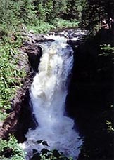
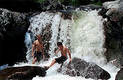
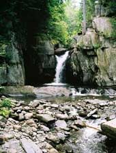
Carrying Place Stream – Easy – 0.25 miles
Spectacular waterfalls and slides highlight this scenic area. The 30-foot high cascading waterfalls and rapids are a result of carved bedrock filled-in by many large boulders. The stream itself drains East Carry Pond into The Kennebec River (called Wyman Lake above the dam).
This scenic location also has a special Colonial American historical importance. It was here that Benedict Arnold, along with his 1,000 men, camped and portaged their bateaux, cannons, and supplies, across the wilderness to the Dead River; heading north to Canada. This was part of a 1775 military campaign intended to capture Quebec and enlist its citizens into the war with Great Britain.
DIRECTIONS: Turn left (north) out of the NCR parking lot and follow Route 201 into the town of Bingham. Turn left onto Route 16 west, crossing the bridge over The Kennebec River. Immediately after crossing the river turn right onto Pleasant Ridge Road. Follow this road past Wyman Dam and travel along the lake for about 4 miles until the road splits. Here you’ll turn right on Carry Pond Road (towards Pierce Pond). Follow this road as it turns to a gravel road for approximately 8 miles. Look for “Carrying Place" signs on right and pull off. This is Carrying Place Stream but the waterfalls are downstream. Hike down a small trail to the falls.
CAUTION: Logging trucks have the right of way on these dirt roads. They are owned by private lumber companies who allow public access but travelers must yield to ALL logging traffic.
Moosehead Lake Region
Moosehead Lake is the largest lake in Maine; supplying water to The Kennebec River. It’s also one of the most popular recreational destinations in Maine. The small towns of Greenville and Rockwood are located on the banks of this majestic lake and they provide shopping, dining, as well as boat and float plane tours of the area. Outdoor activities are endless along the lake’s 400 miles of shoreline, and surrounding mountains
The town of Greenville becomes a “mega-center" for snowmobilers during the winter. Riders explore the area using Maine’s vast ITS (Interconnected Trail System) in addition to club trails in the area. Greenville is also a poplar day trip for snowmobilers staying at North Country Rivers in Bingham.
From Bingham, the ride takes approximately 3 hours. Many restaurants and pubs await you for lunch, and you can be back in your cabin at North Country Rivers by late afternoon. You can also plan an extended trip to explore the Moosehead Lake region more fully.
DIRECTIONS: Turn left (north) out of the NCR parking lot and follow Route 201 into the town of Bingham. turn right onto Route 16 east to the town of Abbott. At the stop sign in Abbot, turn left onto Route 6/15 north. Follow this road for approximately 20 miles to Greenville. The Indian Hill Trading Post is the first gas station/grocery store at the top of the hill as you come into Greenville.
DIRECTIONS BY SNOWMOBILE: From North Country Rivers, follow the ITS 87 north to Moxie Pond. Do not follow the signs to The Forks. Look for the ITS 86 east sign, and follow this trail all the way into Greenville. There are other club trails, cut-offs, and loops along this route so get a current trail map!
Pleasant Pond Mountain – The Appalachian Trail – Moderate–Strenuous – 2.5 miles
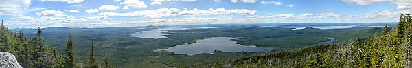
Pleasant Pond Mountain rises steeply over Pleasant Pond just south of The Forks. From the summit which is near the confluence of The Dead and Kennebec Rivers, you can see many of Maine’s High Peaks. The trail itself is part of the Appalachian Trail (AT) and climbs very steeply; gaining 1,200 feet in just 1.2 miles. At the 2,477 foot summit lay charred remains of an old fire warden’s camp and the underpinnings of the old fire tower.
Once you reach the summit the AT continues northeast toward Moxie Pond, Moxie Bald Mountain, and ultimately Katahdin. You can follow the same trail back to the parking area at the base of the mountain along the Pleasant Pond shoreline. Pleasant also makes a great swimming spot in the summer, and there is a very nice sand beach there (along with a lean-to used by AT hikers). The lake itself is almost 200 feet deep; carved out deeply from the continental glaciers during the last ice age.
DIRECTIONS: Turn left (north) out of the NCR parking lot and follow Route 201 to the small town of Caratunk. Turn right onto Caratunk Road and drive for 0.3 mileS to the post office. Turn right at the intersection and follow this road along Pleasant Pond Stream. Once you reach the pond, fork left onto a road which shortly turns to gravel. Continue for 1.8 miles to the north side of Pleasant Pond where there is an Appalachian Trail sign and a small parking area. Follow the trail, the AT, to the right.
NOTE: Click here for information on hiking the moderate to high peaks of Maine
Moxie Bald Mountain – Strenuous – 9.5 miles Total
Moxie Bald Mountain is one of the seven Bald Mountains in the state of Maine and is among the most scenic; with many extended ledges and open areas for a panoramic climb to the summit. The trail follows a 4-mile long ridge (part of The Appalachian Trail – the “AT"), beginning on the southern shore of Moxie Pond.
As the trail begins to climb the mountain, you’ll see Bald Mountain lean-to (a shelter for hikers to stay the night). Continue following the white blazes on the trees as you climb higher. As you reach mile 4.2 there is a blue blazed trail bypassing the summit. So, stay on the AT and follow the white blazes to the summit. At the 2,630 foot summit, a 360-degree panorama awaits and the view is breathtaking. From here, the High Peaks of Maine are visible on a clear day including Sugarloaf, The Bigelows, and Mt. Katahdin.
To continue your hike you may return via the trail you came up, or you can also continue along the AT to the blue blazed-trail on your left and return via the summit cut-off trail you passed earlier in the ascent. The North peak is also accessible by following the AT past the blue blazed cut-off trail to a small side trail on your left. The hike to the North Peak will add approximately 3 miles to your hike.
This trail requires the hiker to cross a few small streams. Also be prepared for cold weather conditions on the summit – even on a warm summer day in the valleys. Since Moxie Bald Mountain is an exposed summit, if the weather is poor, hikers should not proceed to the summit. Also please stay on the trails to minimize trail erosion and to protect the rare alpine vegetation which takes decades to grow even the smallest amount.
DIRECTIONS: Turn left (north) out of the NCR parking lot and follow Route 201 into the town of The Forks (approximately 20 miles north of Bingham). Just before crossing The Kennebec River, turn right onto Lake Moxie Road and follow for about 5.3 miles, passing the trail to Moxie Falls. Once you reach a large body of water (Moxie Pond) turn right onto a dirt road. Follow the dirt road along the lakeshore to the southern end of the pond where white blazes on the trees become noticeable on your right. After traveling this dirt road for 7.9 miles look for a sign on the left that marks the Appalachian Trail (AT). Park your vehicle on the right side of the road to begin your hike.
CAUTION: Logging trucks have the right of way on these dirt roads. They are owned by private lumber companies who allow public access but travelers must yield to ALL logging traffic.
NOTE: Click here for information on hiking the moderate to high peaks of Maine
The Bigelow Range
The Bigelow Mountain Range is part of the High Peaks region just west of North Country Rivers’ Kennebec-Dead Base Resort in Bingham. Many hiking opportunities exist in this area including The Appalachian Trail, Mt. Abraham, The Crockers, Saddleback, Sugarloaf, and the Peaks of Bigelow Range.
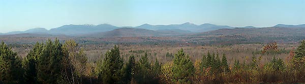
The Bigelow Range runs to the north of Sugarloaf Ski Area and immediately south of Flagstaff Lake. Much of the water utilized for whitewater rafting on the Dead River originates from these very mountains. The Bigelows are impressive bald peaks, visible along various outlooks on the ATV trails surrounding our base in Bingham. They’re also visible south of the Dead River during the bus ride to the Dead River rafting put-in. In the winter, many snowmobile riders also explore the many sections of ITS within this area right from our Bingham Resort Base Complex.
The most popular lookout for viewing the Bigelows is very near our Kennebec-Dead River Resort; just south of Solon on Route 201. Just north of the Route 43 and 201 junction (on top of Robbins’s Hill) there’s a visitor’s center that provides great views of all theses mountains on a clear day. Visiting this area in the morning provides the most detailed views of the mountains while evening visits are great for watching sunsets over them. For more information regarding hikes in the Bigelows or other mountains in the High Peaks refer Cloe Chunn’s book, “50 Hikes in The Maine Mountains", and, “the AMC Maine Mountain Guide".
DIRECTIONS: Travel south on Route 201 to the town of Solon approximately 7 miles. In Solon turn right at the blinking light onto Route 16 West. Follow Route 16 to the town of Kingfield. Once in Kingfield continue following Route 16 West to the Carrabasset Valley. From here you can choose from various hiking, skiing, snowshoeing, or cross-country skiing activities.
BY SNOWMOBILE: Travel south on the ITS 87 from North Country Rivers in Bingham to Solon along the Kennebec River. In Solon take the ITS 84 west to Kingfield where many connections can be made through the High Peaks including the ITS 115, ITS 84, and many club trails. The Lexington Highland club trial is another excellent route from Bingham to Kingfield and offers many spectacular views of The Bigelow Range.
NOTE: Click here for information on hiking the moderate to high peaks of Maine
Penobscot Region Hikes and Scenic Locations
Gulf Hagas Canyon Rim Trail – Strenuous – 10 miles
Gulf Hagas is known as Maine’s Grand Canyon, and one of the best hikes in the state of Maine. This “accessible" 2.5 mile canyon section is tucked deep within Maine wooded wilderness and is part of the Appalachian Trail’s “Hundred Mile Wilderness" section (the longest section of wilderness on the entire AT).
This geologic wonder was carved by the West Branch of the Pleasant River – through slate – creating narrow walls up to 400 feet high. The river itself drops over a fantastic series of waterfalls and rapids and plunges an amazing 500-feet vertically in this 2.5 mile long gorge section! Fortunately, this gorge is now accessible due to logging operations. In 1968, the canyon was declared a “Registered National Landmark" – to preserve it as a wild and scenic area forever.
It must noted that this is a very strenuous hike that can take 7 hours to complete (since you will stop often). The trail is sometimes very steep and demanding. Most hikers start at the traditional trail head – along the AT – at an area known as The Hermitage. From here you follow the AT (with its white blazes on the trees) for about 10-minutes to a point where you’ll have to cross the Pleasant River (take off your boots). Then you take a side trail to the “blue blazed" Gulf Hagas Rim Trail. Here, at Screw Auger Falls the hiker can follow the cut-off trail to the Head of the Gulf or take the Rim Trail, which follows the canyon. Starting at the Head of the Gulf ensures mostly downhill hiking along the Rim Trail.
Another starting place for hiking Gulf Hagas is upstream of the gorge where many experienced kayakers also start this challenging whitewater section. Following the gravel road past The Hermitage trail head, it’s possible to reach the West Branch of the Pleasant River via a road to Llyod Pond. The final hundred yards or so of the road have been gated so you’ll have to park by the Appalachian Mountain Club (AMC) Gate and walk down a snowmobile trail. After crossing the stream on a bridge, look for the trail on the right side of the road. Follow this trail to the Head of the Gulf.
DIRECTIONS: From North Country Rivers’ Penobscot Outpost in Millinocket, turn left at Katahdin Ave./ME-11 and follow for approximately 26.3 miles. Turn right onto Ebeeme Road and in short distance continue on the “Katahdin Iron Works Road". Follow the signs for Gulf Hagas and Pleasant River.
From North Country Rivers’ Kennebec-Dead Resort and Campground take a left onto Route 201 (north) through Bingham. Then turn right onto 16 east. Follow Route 16 east approximately 50 miles into Abbot, through Guilford, through Dover-Foxcroft, and into Milo. Once in Milo take Route 11 north through the small town of Brownville Junction. Travel 12.5 miles to a small dirt road on the left called “Katahdin Iron Works Road". Travel 6.5 miles to the ironworks and a gate house. About 7 miles from the gate house the AT crosses the road at The Hermitage.
CAUTION: Logging trucks have the right of way on these dirt roads. They are owned by private lumber companies who allow public access but travelers must yield to ALL logging traffic.
Mount Katahdin – Strenuous – 11 miles
Mt. Katahdin is one of Maine’s most popular hikes. To Native Americans, the name Katahdin means “Sacred Mountain”. Located in Baxter State Park, this mountain is a demanding, but rewarding hike that should be attempted only in good weather, and with the proper equipment.
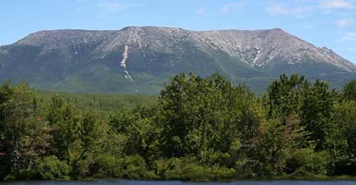
Multiple trails lead to this mile high summit; all have very steep and rugged sections with large boulders that the hiker must deal with. Many hikers of Katahdin enjoy taking the Knife’s Edge trail; a 2-3 foot wide section of trail which drops precipitously on both sides as it travels across one particular ridge section. But no matter which route you take, the summit views are breathtaking and panoramic. The hiker WILL feel on top of the world (and the summit often lies above the clouds).
In addition to Katahdin, MANY other fantastic hiking opportunities await you within Baxter State Park; including “The Owl", “Doubletop", and “Russell Mountain" – to name a few. Information about Katahdin and other hikes in Baxter State Park can be obtained through guide books and at the entrance gate when you arrive. The park is located just 5 miles north of North Country Rivers’ Penobscot River outpost at the Big Moose Inn near Millinocket.
DIRECTIONS: From the North Country Rivers outpost at The Big Moose Inn in Millinocket, travel north on the Baxter Park Road (the paved road to the right). Once at the gate house follow the signs to the desired trail head at Roaring Brook, Katahdin Stream Campground, or Abol Stream Campground.
NOTE: Click here for information on hiking the moderate to high peaks of Maine
|